GEOTECHNICALENGINEERING
RICHMOND HILL
HomeUnderground ExcavationsGeotechnical design of deep excavations

Geotechnical Design of Deep Excavations in Richmond Hill

Evidence-based design. Reliable delivery.

LEARN MORE

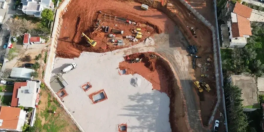
In Richmond Hill, you don't have to dig far to hit the tough stuff—glacial till packed with boulders, layered silts, and groundwater that shows up earlier than the borehole logs suggest. Over the years we've learned that deep excavation design here isn't about applying a textbook solution; it's about reading the Oak Ridges Moraine geology correctly and choosing a support system that works with the ground, not against it. Whether the project is a three-level underground parking off Yonge Street or a utility shaft near the Rouge River tributaries, the difference between a smooth dig and a costly delay often comes down to how well the temporary works are tuned to local stratigraphy. For sites where the till transitions into loose saturated sands, we frequently pair the excavation design with a liquefaction assessment to rule out strength loss under seismic loading—a requirement that Richmond Hill's planning department takes seriously given the proximity to mapped fault zones in southern Ontario.

In Richmond Hill's glacial terrain, a well-designed excavation support system pays for itself the first time it prevents a ground loss or a shutdown.

Our service areas

Methodology and scope

Southern Ontario's freeze-thaw cycles add a dimension to excavation design that warmer climates never deal with. In Richmond Hill, where winter temperatures routinely drop below -15°C, the upper two to three metres of soil can freeze solid, altering lateral earth pressures on shoring walls. Our team accounts for this seasonal shift in the structural analysis, designing soldier pile and lagging systems or secant pile walls that won't crack when the frost heave releases in March. The groundwater table across the moraine varies dramatically—some sites are bone dry at eight metres while others hit artesian conditions at four, especially in the low-lying areas west of Bayview Avenue. We run in-situ permeability tests and install piezometers early, because guessing the pore pressure regime in Richmond Hill's heterogeneous till is a gamble no contractor should take. The geotechnical model also incorporates the stiff clay layers that often sit beneath the till, which can act as a natural basal seal if the wall toe is embedded correctly, reducing the risk of piping during dewatering.
Geotechnical Design of Deep Excavations in Richmond Hill
Technical reference — Richmond Hill

Local geotechnical context

The mistake we see repeatedly in Richmond Hill is treating a deep dig as a standard retaining wall problem. Contractors bring in a one-size-fits-all soldier pile design, hit a perched water pocket in the till, and suddenly the excavation base turns into a slurry pit. The cost of remobilizing pumps, re-engineering the support, and managing the settlement claims from adjacent homeowners on Observatory Lane or Elgin Mills Road can triple the original budget. A proper geotechnical investigation with staged piezometer readings and laboratory shear strength testing on undisturbed Shelby tube samples eliminates most of these surprises. We also insist on pre-construction condition surveys for all structures within the zone of influence—Richmond Hill has plenty of 1980s subdivisions with shallow footings that don't tolerate lateral movement well. The Ontario Building Code requirement for a professional geotechnical review on excavations deeper than 3 metres exists precisely because the consequences of getting it wrong cascade quickly.

Need a geotechnical assessment?

Reply within 24h.

Email: info@geotechnicalengineering.co

Applicable standards

NBCC 2020 – Division B, Part 4 (Structural Design), CSA A23.3-19 – Design of Concrete Structures, ASTM D2487 – Unified Soil Classification System, OPSS.MUNI 206 – Excavation Support Systems, Canadian Foundation Engineering Manual (CFEM), 4th Edition

Reference parameters

ParameterTypical value
Maximum excavation depth analyzedUp to 25 m in urban settings
Soil-structure interaction methodBeam-on-elastic-foundation or FE (Plaxis)
Lateral wall deflection limit (cantilever)0.5% H or 50 mm max
Active earth pressure coefficient (Ka)Rankine or Coulomb, based on wall friction
Groundwater controlDeep wells, wellpoints, or cutoff walls
Seismic design acceleration (NBCC)Site Class D/E spectral values per Richmond Hill coordinates
Monitoring frequency during digDaily inclinometer and settlement readings
Boulder mitigation in tillPre-drilling or chisel reinforcement in pile locations

Common questions

How much does a deep excavation design for a project in Richmond Hill typically cost?

The fee for a complete design package—including geotechnical interpretation, shoring wall analysis, and dewatering plan—generally ranges between CA$2,840 and CA$9,920 depending on excavation depth, footprint, and proximity to adjacent structures. A three-level underground parking with four shoring elevations falls in the mid-upper range, while a deep utility shaft with a simpler geometry sits at the lower end. We provide a fixed-price proposal after reviewing the architectural and structural floor plans.

At what depth does Richmond Hill require a professional geotechnical review for excavations?

Under the Ontario Building Code, any excavation deeper than 3 metres that workers will enter requires a professional geotechnical engineer's review of the support system. In practice, Richmond Hill's building department also triggers a review for shallower digs if they are within the zone of influence of a public right-of-way or an adjacent property, which covers most urban infill lots.

What is the biggest geotechnical challenge when excavating in Richmond Hill's glacial till?

The unpredictability of boulders and perched groundwater. The Halton Till that blankets much of Richmond Hill contains erratic boulders up to a metre in diameter, which can deflect augers and delay pile installation. Meanwhile, sand and silt lenses within the till create isolated water pockets that don't appear on regional maps. We mitigate both by specifying pre-bore probe holes and installing standpipe piezometers at multiple depths before finalizing the shoring design.

How long does the design and approval process take for a deep excavation in York Region?

From the moment we receive the finalized site plan and geotechnical report, a typical design turnaround is two to three weeks for the shoring and dewatering drawings. The municipal permit review through the City of Richmond Hill adds another three to four weeks, assuming no major RFIs. We recommend starting the geotechnical investigation at least eight weeks before the intended construction start date to allow for laboratory testing and any required re-design iterations.

Location and service area

We serve projects in Richmond Hill and surrounding areas.

View larger map